• Starting today August 7th, 2024, in order to post in the Married Couples, Courting Couples, or Singles forums, you will not be allowed to post if you have your Marital status designated as private. Announcements will be made in the respective forums as well but please note that if yours is currently listed as Private, you will need to submit a ticket in the Support Area to have yours changed.

Debunking Pangaea/Continental Drift Theory.

joshua 1 9

Well-Known Member
Site Supporter
May 11, 2015
17,420
3,593
Northern Ohio
✟314,607.00
Country
United States
Gender
Male
Faith
Christian
Marital Status
Married
images

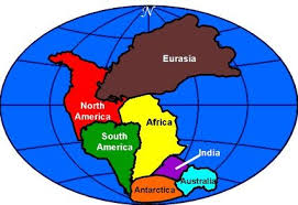
Here is what is taught in our public schools, the theory of Pangaea or the continental drift theory. The theory is that over millions of years the continents have drifted apart and some into each other(India into Eurasia). Notice, how it is in the cartoon format. Do you notice Central America? Neither do I. Now, here is how to debunk this fallacy of evolution, and anyone wanting to use this as a teaching tool/mechanism has my permission to use the mathematical calculations that I have used to debunk this theory. According to the theory of continental drift- the tectonic plates drift at 0.8 inches per year. When you are educated in math you can take a number like 0.8(the distance according to the theory) and times it by 4,500,000,000(years/age of earth according to some scientist ) and get the answer of 3,600,000,000 then you can divide it by 5,280(the feet in one mile) and get the answer of 681818.18 miles, and divide it by 24,901 miles(the circumference of the earth) and get the answer of 27.381. 27 times the tectonic plates have circled the globe, according to the theory of continental drift...that is how much the continents have drifted! It is mathematically impossible! Have a blessed day. Barry Dennis-Commander.
Even if they get the math wrong that does not mean the whole theory is wrong.
 
Upvote 0

RickG

Senior Veteran
Site Supporter
Oct 1, 2011
10,092
1,430
Georgia
✟106,373.00
Faith
Presbyterian
Marital Status
Married
Of course I've heard of these things.

My point is that the puzzle pieces also fit together in the Pacific - and I have never seen a Pangaea map, or any other map, drawn to show THOSE pieces together. The Atlantic pieces are obvious, but so are the Pacific pieces (when you look at the continental shelves).

So, you've got a situation where the plates fit together across the Atlantic AND across the Pacific.

I want to see a map drawn with those recognitions in place. It can be done, but when you do it, you end up with no oceans. You end up with a smaller, all-brown globe. And that's interesting.

If one cannot accept that, that's fine, but then draw the map with the pieces closed in the Pacific. What does that continent look like? Obviously it once EXISTED, because the plates fit. But what did the Atlantic side look like then?
Vicomte13, I think you have a misunderstanding of map projections and what they represent. This is what is called the field of cartography (map making). The pictures you have been looking at are two dimensional and contain distortion. A good example of that would be to compare the size of Greenland on a two dimensional map with that of a three dimensional globe. The two dimensional map shows Greenland very large because when you flatten the globe out everything toward the poles is exaggerated (Mercator projection). On a round globe (3-D) Greenland is quite small, its actual size. One just the opposite and probably the one we see most often in maps showing Pangaea, would be some form of the Mollweide or Eckert projections. Those projections are equal area and show land masses toward the poles correct or near correct in size. The distortion there is that the map is a wide oval.

In the projection below there is no Atlantic or Pacific ocean, only one huge ocean the Panthalassa ocean. And no, you do not wind up with a smaller globe, it was the same size then as now.
1849d21a16a32353a3ac84b9934c2923.jpg
 
Upvote 0

RickG

Senior Veteran
Site Supporter
Oct 1, 2011
10,092
1,430
Georgia
✟106,373.00
Faith
Presbyterian
Marital Status
Married
  • Like
Reactions: Armoured
Upvote 0

Vicomte13

Well-Known Member
Jan 6, 2016
3,655
1,816
Westport, Connecticut
✟108,837.00
Gender
Male
Faith
Catholic
Marital Status
Married
Politics
US-Others
Vicomte13, I think you have a misunderstanding of map projections and what they represent. This is what is called the field of cartography (map making). The pictures you have been looking at are two dimensional and contain distortion. A good example of that would be to compare the size of Greenland on a two dimensional map with that of a three dimensional globe. The two dimensional map shows Greenland very large because when you flatten the globe out everything toward the poles is exaggerated (Mercator projection). On a round globe (3-D) Greenland is quite small, its actual size. One just the opposite and probably the one we see most often in maps showing Pangaea, would be some form of the Mollweide or Eckert projections. Those projections are equal area and show land masses toward the poles correct or near correct in size. The distortion there is that the map is a wide oval.

In the projection below there is no Atlantic or Pacific ocean, only one huge ocean the Panthalassa ocean. And no, you do not wind up with a smaller globe, it was the same size then as now.
1849d21a16a32353a3ac84b9934c2923.jpg
RickG, I think you have misunderstood what I have said. Look at the WEST COAST of South America, the WEST COAST of North America, and the EAST COAST of Asia, Japan and Australia. You have to look at their continental shelves, not just their current coastlines. With a little rotation, you will discover that California, Chile and Peru mesh up with Kamchatka, Japan and Australia. The puzzle pieces fit together across the Pacific the OPPOSITE puzzle picture as the one you have presented, in which the puzzle pieces are closed across the Atlantic.

THAT is what I am talking about. BOTH sides of the continents fit together, not just the Atlantic side.

We only see the Pangea map of the Atlantic side. It's harder to see on the Pacific side because of rotations of the continents, and because you have to look at continental shelves as opposed to present coastlines, but it is nevertheless so that the PACIFIC sides of the continents ALSO fit together, JUST LIKE the Atlantic sides.

So, there was ALSO an OPPOSITE PANGEA, a mirror image that was joined on the OTHER coast.

THAT is what I am talking about.
 
Upvote 0

Vicomte13

Well-Known Member
Jan 6, 2016
3,655
1,816
Westport, Connecticut
✟108,837.00
Gender
Male
Faith
Catholic
Marital Status
Married
Politics
US-Others
I've found water compression information to one mile in the ocean, and it's less than 1%. Can you document your 40% at 25 miles figure. I presume you are saying that at 100 miles and 500 miles the compression is even greater.

The discovery of the compressibility of water under very great pressure into a hot non-crystalline solid is only very recent. The 100 mile figure is a guesstimate, based on the compression required to make solid non-crystalline water.
 
Upvote 0

RickG

Senior Veteran
Site Supporter
Oct 1, 2011
10,092
1,430
Georgia
✟106,373.00
Faith
Presbyterian
Marital Status
Married
Here is a quote from Dr Walt Brown's Hydroplate Theory;

The Data Finally Released. One U.S. Navy scientist, N. Christian Smoot, an evolutionist, spent 32 years precisely mapping the ocean floor. His book, Tectonic Globaloney: Closing Arguments (Author House Press, 2012), describes discoveries on the ocean floor that falsify plate tectonics. Smoot, a veteran of 67 cruises, was responsible for declassifying some of this data for use outside the U.S. Navy. He says he “devoutly believed” the plate tectonic theory, but now knows it is “baloney” or “tectonic globaloney.” Based on features he sees on the ocean floor, Smoot concludes that subduction does not occur, and the seafloor is not spreading.

110425.

http://www.creationscience.com/onlinebook/FAQ229.html#wp13687726
Good grief. :doh:
 
Upvote 0

RickG

Senior Veteran
Site Supporter
Oct 1, 2011
10,092
1,430
Georgia
✟106,373.00
Faith
Presbyterian
Marital Status
Married
I've found water compression information to one mile in the ocean, and it's less than 1%. Can you document your 40% at 25 miles figure. I presume you are saying that at 100 miles and 500 miles the compression is even greater.
I'm surprised it would even be as much as 1%.
 
Upvote 0

Vicomte13

Well-Known Member
Jan 6, 2016
3,655
1,816
Westport, Connecticut
✟108,837.00
Gender
Male
Faith
Catholic
Marital Status
Married
Politics
US-Others
I'm surprised it would even be as much as 1%.

Take a look at the compressed states of water discoveries made in the past few years. It's interesting stuff.

Codex Vaticanus may be older. More probably they are both the "presentation Bibles" that Eusebius had made for various great cities once Constantine made Christianity the official religion. Together, Vaticanus and Sinaiticus give us a complete Alexandrian-type uncial Bible. Of course the two differ - no two manuscripts are the same. And we can learn something from that fact too.
 
Upvote 0

Speedwell

Well-Known Member
May 11, 2016
23,928
17,626
82
St Charles, IL
✟347,280.00
Country
United States
Gender
Male
Faith
Other Religion
Marital Status
Married
The discovery of the compressibility of water under very great pressure into a hot non-crystalline solid is only very recent. The 100 mile figure is a guesstimate, based on the compression required to make solid non-crystalline water.
Have you got a source for that?
 
Upvote 0

chilehed

Veteran
Jul 31, 2003
4,732
1,399
64
Michigan
✟250,024.00
Faith
Catholic
Marital Status
Married
I don't want to write a treatise (I have several at my website, lol). You are correct on the energy (the "a lot" part, not on the "molten today" part). If one approaches it from the actual ancient writings that agree with the Bible, and uses those to define which of the other acient writings are valid (admittedly, that is already an assumption), one gets a consistent theory. It's shocking at first, but it is scientifically justifiable, and once you get the idea in your head, you start to see that it makes sense. Suppose that before writing was invented, a small group of intelligent people set out to rule the world. Next, suppose they built a technology capable of controlling the weather. Next, suppose that as greed mounted, the multiplied this technology to where it became unstable. Now, suppose that this technology literally sucked out huge quantities of electromagnetic energy from the earth's magnetic field, saved it locally, and moved it around to create lightning hoping to create rain. Now suppose that the earth's center is in fact molten metal, and oscillations created by the unstable electromagnetic field caused the earth's center to bounce up and down against Pangea on one side, and the open ocean on the other. One day, the molten field struck Pangea hard from below and shattered it into two pieces, one (now called the Americas 1/3 the original size) and the other (Eurasia-Africa 2/3 the original), with smaller islands (including Antarctica and Australia) splitting off. In such a case, Coriolis forces would have moved the continents very rapidly for a few days. Eventually the earth would have settled into some kind of temporary equilibrium, and possibly after a couple more later corrections (like say in Joshua's time and King Hezekiah's time) stabilized almost completely. Now you have another theory to explain continental drift. And this theory is completely consistent with evolution, creationism, or any blend you like, since it deals only with events that could have happened as recently as 3300BC or so.

Of course it raises lots of other questions about how this all worked, where is the archeology, how did we forget, etc.. But like I say, I don't want to write a treatise here. But this is actually what the ancient books say happened. Well, not in our words. It took me quite a while, and several languages to get it together. But I will answer the energy question by saying that a typical machine was capable of storing and directing approximately 10 times the voltage of our most powerful nuclear reactors today, and at its peak, there were dozen of machines operating simultaneously. That's what the writings, existing models and tech specs imply.
This is as absurd as Chariots of the Gods. Perhaps more so.
 
  • Like
Reactions: Armoured
Upvote 0

RickG

Senior Veteran
Site Supporter
Oct 1, 2011
10,092
1,430
Georgia
✟106,373.00
Faith
Presbyterian
Marital Status
Married
RickG, I think you have misunderstood what I have said. Look at the WEST COAST of South America, the WEST COAST of North America, and the EAST COAST of Asia, Japan and Australia. You have to look at their continental shelves, not just their current coastlines. With a little rotation, you will discover that California, Chile and Peru mesh up with Kamchatka, Japan and Australia. The puzzle pieces fit together across the Pacific the OPPOSITE puzzle picture as the one you have presented, in which the puzzle pieces are closed across the Atlantic.

THAT is what I am talking about. BOTH sides of the continents fit together, not just the Atlantic side.

We only see the Pangea map of the Atlantic side. It's harder to see on the Pacific side because of rotations of the continents, and because you have to look at continental shelves as opposed to present coastlines, but it is nevertheless so that the PACIFIC sides of the continents ALSO fit together, JUST LIKE the Atlantic sides.

So, there was ALSO an OPPOSITE PANGEA, a mirror image that was joined on the OTHER coast.

THAT is what I am talking about.

I see what you are projecting but you are unaware of all the information that contradicts what you are saying. Going back to Wegener, his discovery and alignment of the super-continent (Pangaea) was based on not only the shape of the continents as they seemed to fit, but the matched statigraphics and fossils when connected as well. Your alignment will not match that. Additionally, the matching of paleomagnetism in both the continental and oceanic crust and time-lines of their movement and direction do not match you connections. If they did they would be shown as you want them to be, but that is why you can't find any such map, the physical data just doesn't support it. There is much more to it than looking at it and thinking it matches.

Here's an educational slide program I think you will be interested in.
http://image.slidesharecdn.com/ch02...1/95/plate-tectonics-12-638.jpg?cb=1404948131
 
Upvote 0

Vicomte13

Well-Known Member
Jan 6, 2016
3,655
1,816
Westport, Connecticut
✟108,837.00
Gender
Male
Faith
Catholic
Marital Status
Married
Politics
US-Others
Water is about as compressible as rock, basalt for example.

Under normal conditions. But under high pressures, water is compressible, and becomes a non-crystalline solid.

At about 1 million psi, water shrinks to become solid ice at temperatures greatly exceeding the boiling point of water at std temp and pressure.
 
Upvote 0

RickG

Senior Veteran
Site Supporter
Oct 1, 2011
10,092
1,430
Georgia
✟106,373.00
Faith
Presbyterian
Marital Status
Married
Under normal conditions. But under high pressures, water is compressible, and becomes a non-crystalline solid.

At about 1 million psi, water shrinks to become solid ice at temperatures greatly exceeding the boiling point of water at std temp and pressure.
Would you provide a source for this please.
 
Upvote 0

Vicomte13

Well-Known Member
Jan 6, 2016
3,655
1,816
Westport, Connecticut
✟108,837.00
Gender
Male
Faith
Catholic
Marital Status
Married
Politics
US-Others
Would you provide a source for this please.

My source was one of the many articles available if you Google "super compression of water" or "new states of compressed water". In one of the articles, it said "70,000 atmospheres", which is not an easy number, so I converted atmospheres to psi and wrote "about 1 million psi". The source of the calculation is me. The source of the 70,000 atmospheres was one of the articles. There are a lot of articles about the newly discovered states of solid supercompressed water.

I remember being interested in it because back in my naval architecture schooling day days, the incompressiblity of water was one of those givens of the science. So I was interested to learn that water really does compress, significantly, in the lab under unusual conditions of high pressure. That doesn't throw out plain vanilla earth-science physics, but it means that at extremes of temperature and pressure, things we are accustomed to behaving a certain way behave really differently. And that's cool.
 
Upvote 0

RickG

Senior Veteran
Site Supporter
Oct 1, 2011
10,092
1,430
Georgia
✟106,373.00
Faith
Presbyterian
Marital Status
Married
My source was one of the many articles available if you Google "super compression of water" or "new states of compressed water". In one of the articles, it said "70,000 atmospheres", which is not an easy number, so I converted atmospheres to psi and wrote "about 1 million psi". The source of the calculation is me. The source of the 70,000 atmospheres was one of the articles. There are a lot of articles about the newly discovered states of solid supercompressed water.

I remember being interested in it because back in my naval architecture schooling day days, the incompressiblity of water was one of those givens of the science. So I was interested to learn that water really does compress, significantly, in the lab under unusual conditions of high pressure. That doesn't throw out plain vanilla earth-science physics, but it means that at extremes of temperature and pressure, things we are accustomed to behaving a certain way behave really differently. And that's cool.
Okay thanks.
 
Upvote 0

Commander

A son of God.
Apr 10, 2015
830
99
Oklahoma
✟16,562.00
Faith
Christian
Marital Status
Married
No, that's not what the theory states.

Plates move at different rates.

Your post is profoundly demonstrative of not understanding the basic science you are trying to refute. In an almost childish map you point out you don't see central America? Why would you mention that? Is that an argument? You do understand that plate tectonics creates and destroys land, and transforms landscapes, correct?

You start with 4.5 billion years.... you understand that the Earth had to cool down and form plates, right?

Most importantly this topic is pointless because we can measure continental drift in real time. Ignoring geological evidence, fossil evidence, evidence from seafloors... etc etc...

Satellites and antennae have been used to measure increased/decreased distance between locations over time.

This topic is not up for debate. It belongs in the same group of absurdities as flat earth theories.

Yeah they had to cool down from plates: "Partly by analogy to what is known about the Moon, Earth is considered to have differentiated from an aggregate of planetesimals into its core, mantle and crust within about 100 million years of the formation of the planet, 4.6 billion years ago." from https://en.wikipedia.org/wiki/Crust_(geology) (click on-did you mean crust geology) That means it cooled down within 100 million years of the formation of the planet(Earth). Yes, according to evolutionary scientist we would use 4.5 billion years in the calculation. There is no debate that the theory is absurd. Circulating the globe 27 times, yeah that is absurd. Have a blessed day.
 
Upvote 0

Commander

A son of God.
Apr 10, 2015
830
99
Oklahoma
✟16,562.00
Faith
Christian
Marital Status
Married
To overturn Plate Tectonic Theory would win him the Nobel Prize. All it would take is for him to present evidence that can be tested and verified by the scientific community supporting his claims.
Rick we know that it cannot be scientifically proven, since science is the intellectual and practical activity encompassing the systematic study of the structure and behavior of the physical and natural world through observation and experiment. But, it can be mathematically proven(using what evolutionary science tells us) that the earth/universe is not as old as evolutionary scientist say that it is. For the numbers that evolutionary scientist use are exaggerated. Have a blessed day.
 
Upvote 0