- Jun 15, 2017
- 7,438
- 2,794
- Country
- United States
- Faith
- Christian
- Marital Status
- Married
- Politics
- US-Republican
By popular demand, I decided to bring my posts from the Christians only section to another part of the forum accessible to non Christians as well.
Old Earth Geology
Old Earth Geology Part 2 (The Grand Canyon)
I figured I would open an area of dicussion here for non Christians and YECs of this area to comment if they would like. Part one goes as follows....
-------------------------------------------------------------------------------------------------
-------------------------------------------------------------------------------------------------
-------------------------------------------------------------------------------------------------
I figured I would make a thread on the geology of New York, to see what Young Earth Creationists might think.
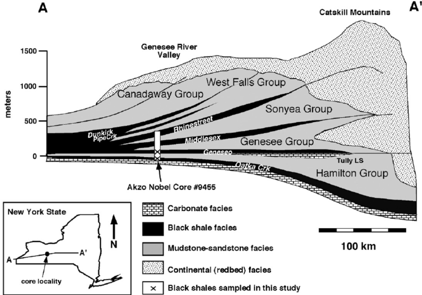
The discussion begins with the diagram below.
Genesee Group (NYDg;4)
Sonyea Group (NYDs;5)
Angola and Rhinestreet Shales (NYDwf;4)
Machias Formation (NYDcy;4)
At the base, limestone. Limestone largely consisting of microscopic carbonaceous shells. Derived from deep sea shelled organisms. These are rocks formed at great depths.
Dark carbonaceous shales (identified in the figure as black shale facies) are rich in organics. Formed in anoxic environments without oxygen for decomposition. With higher amounts of organic material, shales take on a dark black color. With less oxygen, oxygen poor environments yield precipitation of sulfide minerals.
These dark shales form in an environment also of a deep sea, but with influence from nearby deposition of sediment.
Above the black shale facies are mudstone-sandstone facies. Shales again, but with higher oxygen content. Shallow waters allow for circulation of oxygen forming minerals like hematite (FeO2) and Magnetite (FeO3). The rocks take on a lighter hue. Sandstones, formed in shallow marine and terrestrial environments (much like the sandy beaches of today).
These are the rocks of shallow marine and a terrestrial beach like environment.
Above these rocks still, the Catskill Devonian red beds. Highly oxidated. Lithologies found in fining upward sequences with turbidites, sorted by density, with conglomerates (rocks formed in tumbling depositional environments).
-----------------------------------------------------
Collectively, we have 5 groups of rock, each group having the sequence of rocks above.
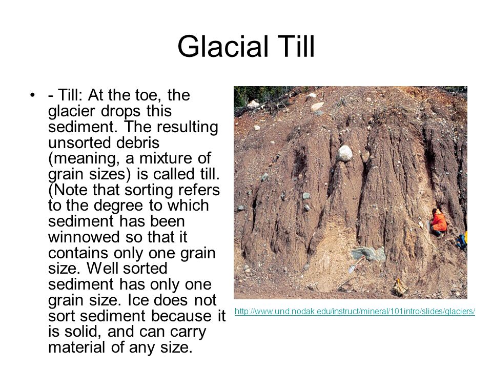
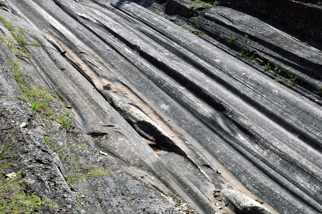
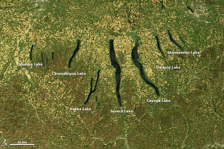
Beyond that further, atop the Devonian shale is glacial till (unsorted, not deposited by water), glacial moraines, drop stones, glacial striations, lakes in a north to south direction (carved by glaciers moving in a north to south direction)
These are traits of Pleistocene ice ages.
--------------------------------------------------------------
Uniformitarianism has a simple explanation. The Acadian Orogeny.
As continental crust advances from the ocean in a western direction into what was then central america, mountain ranges are eroding, depositing sediment. Deltas form along the mountain range. Sea level rises, deeper waters give rise to anoxic carbonaceous shales. Sea level drops, the sea becomes aerated, more oxidized minerals form, rocks change color and chemistry.
Fast forward to the pleistocene epoch, ice comes down from the north, carves the great lakes and finger lakes, then deposits unsorted glacial till as it melts away.
And the fossils match. No dinosaurs in NY as the rocks are twice as old as the earliest dinosaurs. No mammals, no birds. Tetrapods are present (as predicted, tetrapods are of the devonian period). No bunny rabbits. Just devonian tetrapods and fish.
--------------------------------------------------------------
How could such a complex geology ever be explained as something to have formed within 6000 years?
------------------------------------------------------------------------------------------------
-------------------------------------------------------------------------------------------------
-------------------------------------------------------------------------------------------------
Part 2, goes as follows
I enjoyed Old Earth Geology (Part 1)
Old Earth Geology
Old Earth Geology Part 1 was written as a challenge to young earthers. I requested some sort of feasible explanation from a young earth point of view for the geologic qualities seen in New York.
Young earthers were unable to explain the geologic features of New York. So, I decided to make another post, Part 2. And Part 1 is still open for discussion for anyone who would like to take on the challenge.
Part 2.
The East Kaibab Monocline and Butte Fault.
View attachment 213665
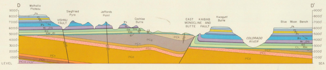
The Part 2 challenge for young earthers is simple. Explain how young earth flood geology can account for the sequence, offeset, and unconformities of the above diagram.
I suppose at a later time i could give the uniformitarian explanation.
But I would like to hear the young earthers explanation for the above diagram, and how such an area could form during a global flood.
Also, these are all paleozoic rocks by the way, they superpositionally predate the K-T boundary and the mesozoic.
From an old earth perspective, the stages of development at the east kaibab fault are pretty straight forward.
Both old and young earth creationists recognize an order of operations, involving deposition of layers on the bottom, prior to layers on the top. And with that...
To begin, we have deposition/formation of
PCb
PCh
PCs
PCd
PCc
PCn
PCg and
PCk
These were hardened, solidified strata, and the eastern side of the diagram was uplifted relative to the left side. These layers were also offset, and at some degree, were tilted toward the east.
The top layers were eroded away, evenly, down to PCg on the right side.
Then we have the deposition and formation of
Cl
Cba
Cm
Otb
Mr
Ps
Pe
Ph
Pc
Pt and
Pk
Trmo
Trc
Tm
Jk
Jn
Jc
Je
Kd
Kt
Ksc
Kw
The right side was then uplifted during compressional faulting. Faults propogated up to the cretaceous. All of these layers must have been hardened and solidified for the occurrence and development of propogating reverse slip faulting, which brought the east side of the fault back down (but not as far as it was previously uplifted) and also resulted in the formation of synthetic and antithetic faulting beyond the primary fault.
This kind of faulting doesnt occur in soft layers of wet or saturated flood sediments, this type of fracturing occurs in solid rock. These rocks, just as those previously faulted, were hardened, solidified, rocks. Not mushy, quick deposited, flood mush.
Then you have deposition of Kk.
All the while, during this recent phase of uplift, you have extensive erosion and deposition caused by uplifted streams and rivers across the region of the grand canyon and beyond.
This is your relative dating order of operations for the diagram in the original post. This is already something that is far beyond the capabilities of a global flood or a young earth to account for. And, this is without even discussing the qualities of each of the above listed formations, things like what they are made of, and what fossils are present within them.
And people seem to somehow believe that a flood did this, or that it happened in 1 year.
And all of this happened, superpositionally before the K-T extinction. There are dinosaur tracks, dinosaur nests, ya know, there is evidence that dinosaurs lived and walked and did dinosaur things throughout these layers.
So, I would ask anyone, where does a global flood that resulted in the extinction of the above mentioned dinosaurs, fit into this picture?
Old Earth Geology
Old Earth Geology Part 2 (The Grand Canyon)
I figured I would open an area of dicussion here for non Christians and YECs of this area to comment if they would like. Part one goes as follows....
-------------------------------------------------------------------------------------------------
-------------------------------------------------------------------------------------------------
-------------------------------------------------------------------------------------------------
I figured I would make a thread on the geology of New York, to see what Young Earth Creationists might think.
The discussion begins with the diagram below.
Genesee Group (NYDg;4)
Sonyea Group (NYDs;5)
Angola and Rhinestreet Shales (NYDwf;4)
Machias Formation (NYDcy;4)
At the base, limestone. Limestone largely consisting of microscopic carbonaceous shells. Derived from deep sea shelled organisms. These are rocks formed at great depths.
Dark carbonaceous shales (identified in the figure as black shale facies) are rich in organics. Formed in anoxic environments without oxygen for decomposition. With higher amounts of organic material, shales take on a dark black color. With less oxygen, oxygen poor environments yield precipitation of sulfide minerals.
These dark shales form in an environment also of a deep sea, but with influence from nearby deposition of sediment.
Above the black shale facies are mudstone-sandstone facies. Shales again, but with higher oxygen content. Shallow waters allow for circulation of oxygen forming minerals like hematite (FeO2) and Magnetite (FeO3). The rocks take on a lighter hue. Sandstones, formed in shallow marine and terrestrial environments (much like the sandy beaches of today).
These are the rocks of shallow marine and a terrestrial beach like environment.
Above these rocks still, the Catskill Devonian red beds. Highly oxidated. Lithologies found in fining upward sequences with turbidites, sorted by density, with conglomerates (rocks formed in tumbling depositional environments).
-----------------------------------------------------
Collectively, we have 5 groups of rock, each group having the sequence of rocks above.
Beyond that further, atop the Devonian shale is glacial till (unsorted, not deposited by water), glacial moraines, drop stones, glacial striations, lakes in a north to south direction (carved by glaciers moving in a north to south direction)
These are traits of Pleistocene ice ages.
--------------------------------------------------------------
Uniformitarianism has a simple explanation. The Acadian Orogeny.
As continental crust advances from the ocean in a western direction into what was then central america, mountain ranges are eroding, depositing sediment. Deltas form along the mountain range. Sea level rises, deeper waters give rise to anoxic carbonaceous shales. Sea level drops, the sea becomes aerated, more oxidized minerals form, rocks change color and chemistry.
Fast forward to the pleistocene epoch, ice comes down from the north, carves the great lakes and finger lakes, then deposits unsorted glacial till as it melts away.
--------------------------------------------------------------
How could such a complex geology ever be explained as something to have formed within 6000 years?
------------------------------------------------------------------------------------------------
-------------------------------------------------------------------------------------------------
-------------------------------------------------------------------------------------------------
Part 2, goes as follows
I enjoyed Old Earth Geology (Part 1)
Old Earth Geology
Old Earth Geology Part 1 was written as a challenge to young earthers. I requested some sort of feasible explanation from a young earth point of view for the geologic qualities seen in New York.
Young earthers were unable to explain the geologic features of New York. So, I decided to make another post, Part 2. And Part 1 is still open for discussion for anyone who would like to take on the challenge.
Part 2.
The East Kaibab Monocline and Butte Fault.
View attachment 213665
The Part 2 challenge for young earthers is simple. Explain how young earth flood geology can account for the sequence, offeset, and unconformities of the above diagram.
I suppose at a later time i could give the uniformitarian explanation.
But I would like to hear the young earthers explanation for the above diagram, and how such an area could form during a global flood.
Also, these are all paleozoic rocks by the way, they superpositionally predate the K-T boundary and the mesozoic.
From an old earth perspective, the stages of development at the east kaibab fault are pretty straight forward.
Both old and young earth creationists recognize an order of operations, involving deposition of layers on the bottom, prior to layers on the top. And with that...
To begin, we have deposition/formation of
PCb
PCh
PCs
PCd
PCc
PCn
PCg and
PCk
These were hardened, solidified strata, and the eastern side of the diagram was uplifted relative to the left side. These layers were also offset, and at some degree, were tilted toward the east.
The top layers were eroded away, evenly, down to PCg on the right side.
Then we have the deposition and formation of
Cl
Cba
Cm
Otb
Mr
Ps
Pe
Ph
Pc
Pt and
Pk
Trmo
Trc
Tm
Jk
Jn
Jc
Je
Kd
Kt
Ksc
Kw
The right side was then uplifted during compressional faulting. Faults propogated up to the cretaceous. All of these layers must have been hardened and solidified for the occurrence and development of propogating reverse slip faulting, which brought the east side of the fault back down (but not as far as it was previously uplifted) and also resulted in the formation of synthetic and antithetic faulting beyond the primary fault.
This kind of faulting doesnt occur in soft layers of wet or saturated flood sediments, this type of fracturing occurs in solid rock. These rocks, just as those previously faulted, were hardened, solidified, rocks. Not mushy, quick deposited, flood mush.
Then you have deposition of Kk.
All the while, during this recent phase of uplift, you have extensive erosion and deposition caused by uplifted streams and rivers across the region of the grand canyon and beyond.
This is your relative dating order of operations for the diagram in the original post. This is already something that is far beyond the capabilities of a global flood or a young earth to account for. And, this is without even discussing the qualities of each of the above listed formations, things like what they are made of, and what fossils are present within them.
And people seem to somehow believe that a flood did this, or that it happened in 1 year.
And all of this happened, superpositionally before the K-T extinction. There are dinosaur tracks, dinosaur nests, ya know, there is evidence that dinosaurs lived and walked and did dinosaur things throughout these layers.
So, I would ask anyone, where does a global flood that resulted in the extinction of the above mentioned dinosaurs, fit into this picture?
Last edited:
